AI-translated from the Chinese original View original
I went to Kyoto for the autumn colors in 2025 and stayed near Umeda in Osaka for two days along the way. At first, it felt much like any other city. After walking around for a while, though, I got curious about how the underground passages and second-floor walkways around JR Osaka Station all fit together. I’d only explored JR Osaka Station, the Hankyu station, and a few nearby malls, but I was already wondering if this might be one of the most intricate pedestrian networks in the world.
When I looked it up later, I found that even Osaka Station City’s neighborhood guide calls it the “Umeda Maze.” Guinness World Records recognizes Tokyo’s Shinjuku Station as the busiest railway station in the world by passenger traffic. In a 2019 J Town Net reader poll asking which station felt most like a maze, Osaka (Umeda) came first and Shinjuku came second. Osaka Station City neighborhood guide · Guinness World Records · Reader poll results
I’ve always liked exploring open-world games. The more complicated the map, the more I want to wander around and see where the paths I missed lead. Umeda gave me that same feeling. I kept thinking about it after I got home, and one day I came across JR West’s 3D map of Osaka Station while browsing online. That’s what got this project started.
A Brief Introduction to Umeda
Before the first Osaka Station was built, Umeda was a low-lying area north of Osaka’s old city center, dotted with fields and waterways. Today it’s one of Osaka’s main commercial districts, with department stores and shopping centers clustered around the stations.
The first Osaka Station opened in 1874 with the railway between Osaka and Kobe. Hanshin, Hankyu, and the Osaka municipal subway later opened stations nearby. The stations were built at different times, each with its own concourses and entrances. As more stations and department stores opened, figuring out how to get people from one station to another became a practical problem.
To ease congestion at street level, Umeda began building underground shopping streets in the 1960s. The Umeda Underground Center, now Whity Umeda, opened in 1963 and linked subway entrances, department stores, and nearby buildings. The Dojima Underground Shopping Center opened later and extended the pedestrian network south from Nishi-Umeda. People could shop along the way or simply use the passages to change trains.
After Osaka Station City opened in 2011, second-floor walkways gradually linked the station and surrounding shopping centers, giving pedestrians a route north to Grand Front Osaka and the Umekita district. Over more than a century, stations, shops, and the passages between them were built in stages. Routes accumulated underground, at street level, and on the second floor. Two places can look close from the street, yet getting between them might mean walking through an underground mall or going upstairs and cutting through a building.
Further reading · The development of northern Osaka · History of Osaka’s underground shopping streets
As of 2026, Umeda’s pedestrian network connects seven main stations.
JR Osaka Station
Operated by JR West, Osaka Station sits at the center of the Umeda station district. Trains on the Osaka Loop Line, JR Kyoto Line, and JR Kobe Line all stop here. JR Osaka Station map
The first Osaka Station opened in 1874 with the railway between Osaka and Kobe. When Osaka Station City opened in 2011, its vast roof and the bridge across the platforms became landmarks. The Umekita underground platforms opened in 2023 and connect to the older part of the station via a passage inside the ticket gates. History of Osaka Station City · Umekita underground platforms

 Hankyu Osaka-umeda Station
Hankyu Railway’s terminal sits on the north side of the Umeda station district. The three sets of platforms for Kyoto, Takarazuka, and Kobe are side by side on the third floor. Hankyu station guide
Hankyu’s predecessor opened Umeda Station in 1910, south of what was then the national railway’s Osaka Station. As passenger numbers grew, the station moved north to its current site. The expansion was completed in 1973. History of Hankyu Osaka-umeda Station
 Umeda Station, Midosuji Line
Osaka Metro operates Umeda Station near the middle of the district. The Midosuji Line runs north toward Shin-Osaka and south through Shinsaibashi and Namba. Public passages outside the ticket gates lead to JR Osaka Station and the underground shopping streets. Midosuji Line Umeda Station guide
Japan’s first publicly operated subway opened between a temporary Umeda Station and Shinsaibashi in 1933. The permanent station opened in 1935. Osaka Metro’s Midosuji Line station history
 Hanshin Osaka-Umeda Station
Hanshin Electric Railway operates the terminus of the Hanshin Main Line next to the Hanshin department store. Trains run from here toward Kobe. The platforms and East Exit are both on B2, one floor below the Department Store Exit. Hanshin station guide
Hanshin extended the line from Deiribashi to Umeda in 1906, when the station was still at street level. In 1939, it moved Umeda Station to its current underground site to connect with the subway along Midosuji. Hanshin’s account of Umeda Station · History of Hanshin Electric Railway
 Higashi-Umeda Station, Tanimachi Line
Osaka Metro’s Higashi-Umeda Station sits southeast of Umeda Station on the Midosuji Line. Whity Umeda provides an underground connection between them. Higashi-Umeda Station guide
The first section of the Tanimachi Line opened in 1967 between Higashi-Umeda and Tanimachi 4-chome. The underground shopping street was extended north in 1974, creating a continuous underground walking route from Higashi-Umeda to the Hankyu station. Osaka Municipal Transportation Bureau records · History of Osaka’s underground shopping streets
 Nishi-Umeda Station, Yotsubashi Line
Osaka Metro operates Nishi-Umeda Station, the northern terminus of the Yotsubashi Line. Underground passages outside the concourse connect it to the pedestrian network on the west side of Umeda. Nishi-Umeda Station guide
Nishi-Umeda Station opened in 1965 when the Osaka municipal subway extended the Yotsubashi Line north from Daikokucho. Transport history of Osaka’s Naniwa Ward
 JR Kitashinchi Station
Operated by JR West, Kitashinchi is an underground station on the south side of Umeda. The JR Tozai Line runs east toward Kyobashi and west toward Amagasaki. JR Kitashinchi Station map
Kitashinchi Station opened with the JR Tozai Line in 1997. From Nishi-Umeda and Kitashinchi, public passages continue south into the Dojima Underground Shopping Center. JR West station opening records · Osaka’s underground shopping facilities
The Interactive Tour
Japan does a good job of keeping maps and guides for public facilities up to date. I suspect disaster preparedness is part of the reason. In Umeda, railway, underground mall, and commercial property operators publish plenty of downloadable station maps, floor plans, and neighborhood maps on their websites. Finding similar material in China has been a different experience for me. Sometimes I have to dig through WeChat mini programs or Xiaohongshu, and a complete guide can be hard to find on an official website.
Using those public guides and OpenStreetMap (OSM) data, and with some help from AI, I turned Umeda’s stations and pedestrian network into the 3D map below.
The map’s geometry, facility locations, and routes are illustrative. When traveling, follow signs on site and information from the operators.
Building the Map
At first, I only planned to model JR Osaka Station. JR West’s official station map shows the platforms, ticket gates, stairs, and connecting bridges together in one 3D view. It even shows how the Umekita underground platforms relate to the station above ground. I wanted to use AI to recreate that effect in a map readers could rotate, with floors they could pull apart to follow the stairs and passages for themselves.
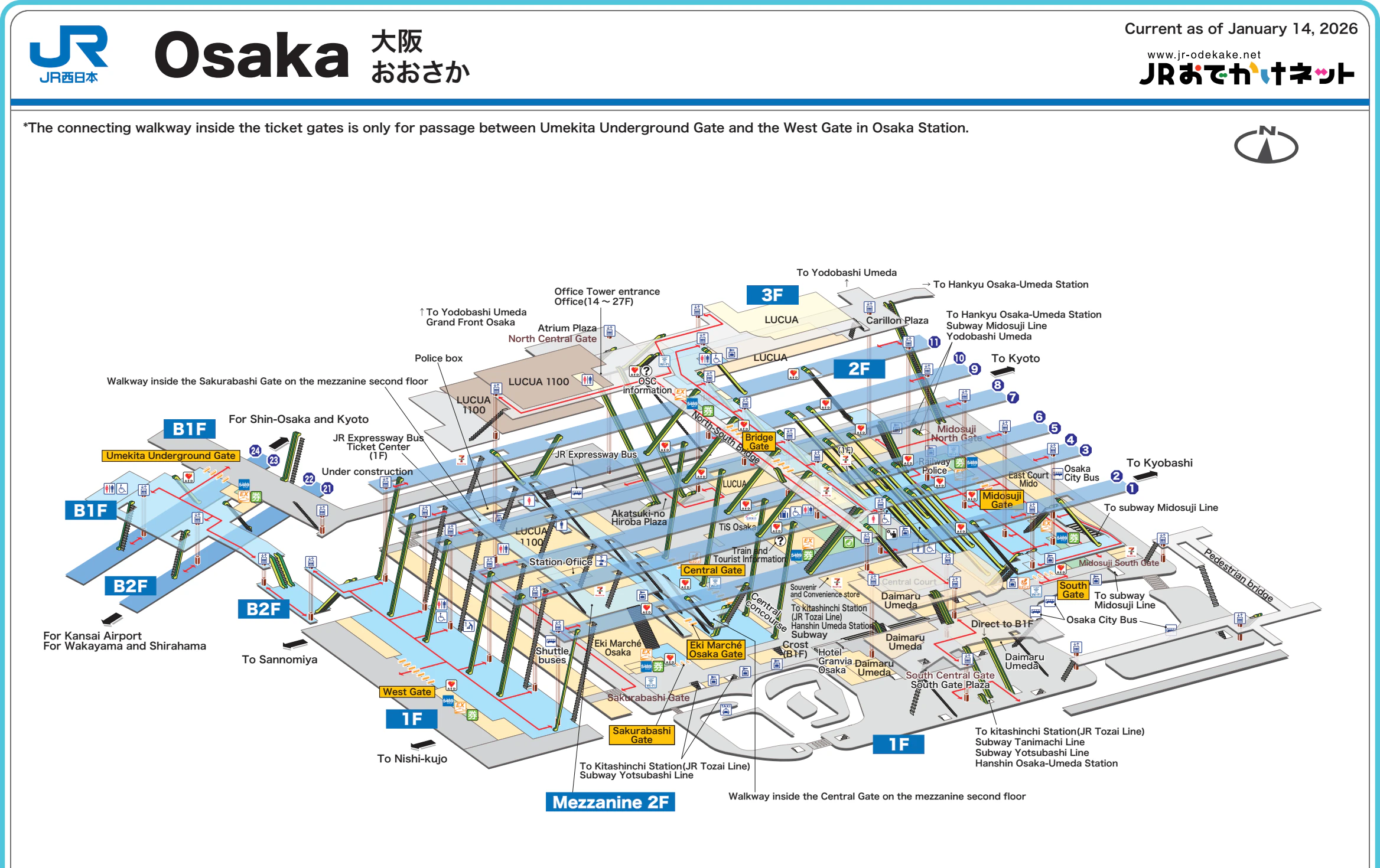
Once I had a model of Osaka Station, I gradually added the neighboring stations. I started by building simplified models from each operator’s station maps and other materials, then tried connecting them directly. On its own, each model did a decent job of showing how the levels and facilities fit together. Put them together, though, and the scale and relative orientation could be off, making it hard to recreate what it feels like to walk through Umeda’s concourses, underground shopping streets, and walkways. The longer I worked on it, the more I thought the underground network was the most interesting part.
I scrapped the first design and rebuilt it. I used map data to put the stations into a single coordinate system, corrected their distances and orientations relative to one another, and then rebuilt the passages using underground walking maps I could find. Even after the outlines lined up, I still had to check where the passages reached street level. I used stair and elevator entrances I could locate as reference points, then went back and adjusted the alignment and junctions of the underground passages. With those passages aligned to the same reference, it was easier to see what you actually pass on the walk from outside one station’s ticket gates to another station.
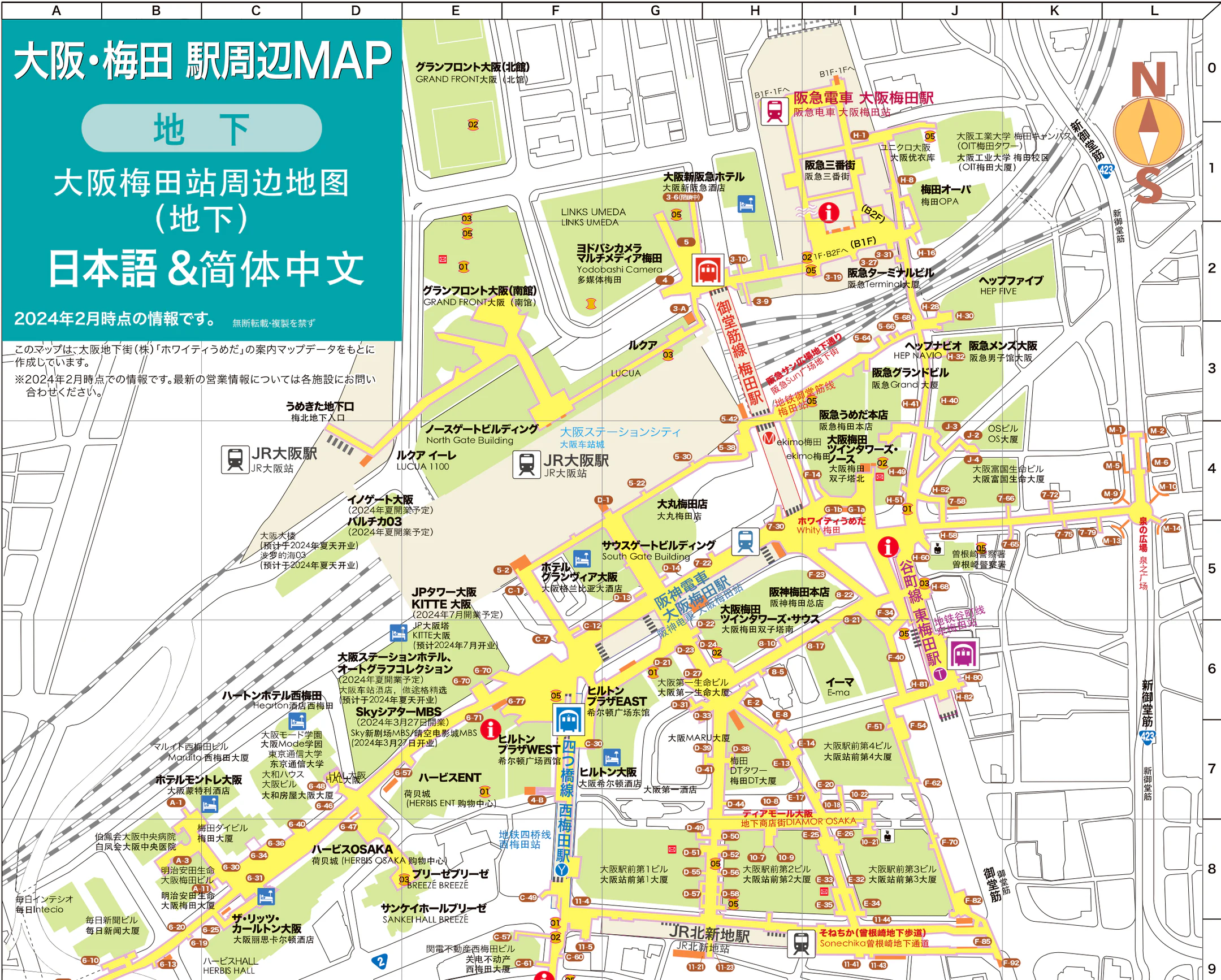
I tracked down this reference map of the underground shopping streets. The yellow areas mark pedestrian space below street level. Following them shows how Whity Umeda, the area around Hanshin Osaka-Umeda Station, and DIAMOR Osaka connect. The numbered entrances are also handy for checking against street-level maps. UMEDA CONNECT neighborhood maps
The overview keeps the buildings and roads above ground as reference points. It also shows concourses, platforms, and public passages on separate levels.
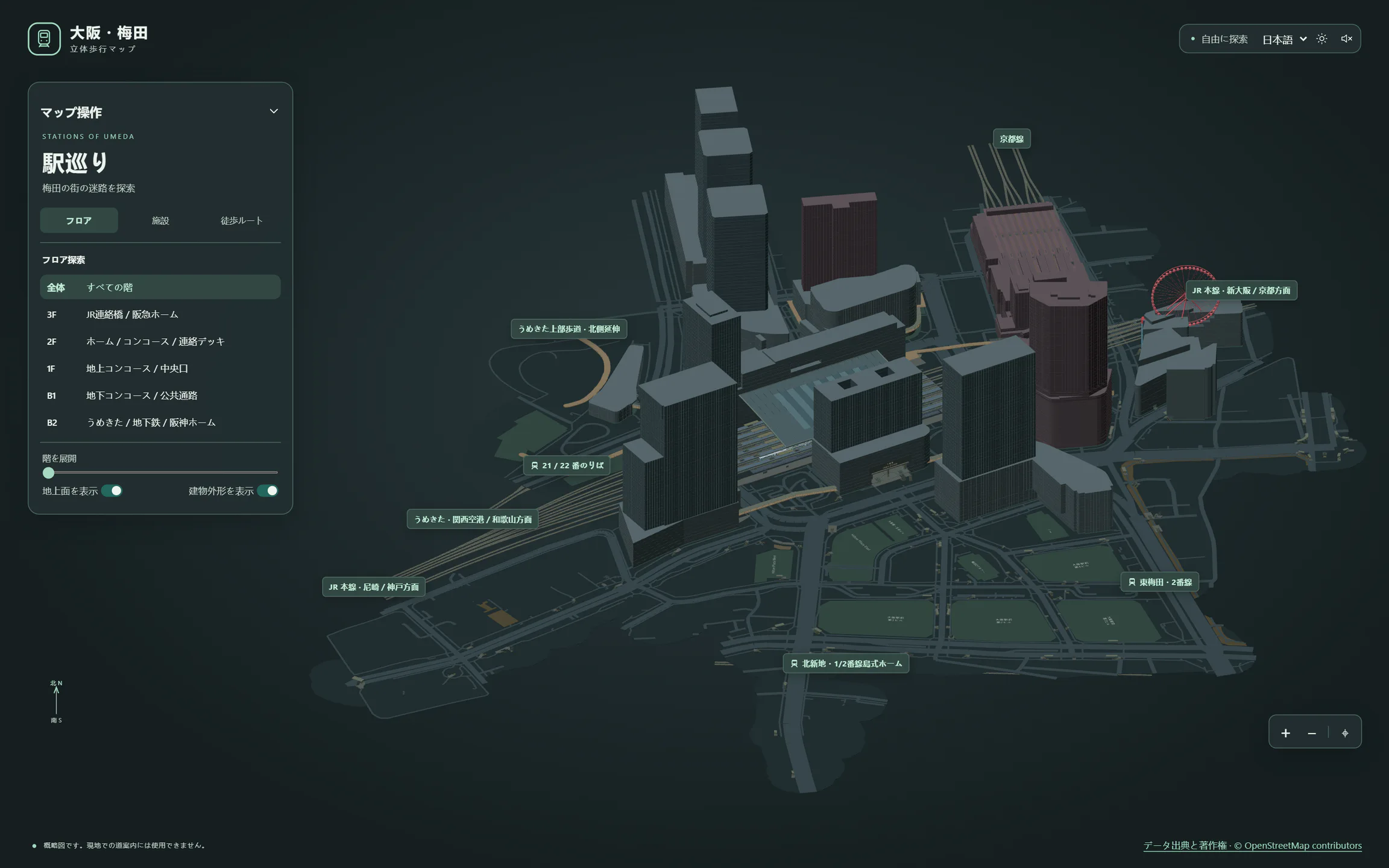
I mainly used OpenStreetMap’s roads and building footprints to position features at street level, and PLATEAU as a reference for the shape and size of some buildings. Some height differences between floors and some passage widths could only be approximated. I used TypeScript and Three.js to bring stations, buildings, and public spaces into the same coordinate system. The map includes source information and credits.
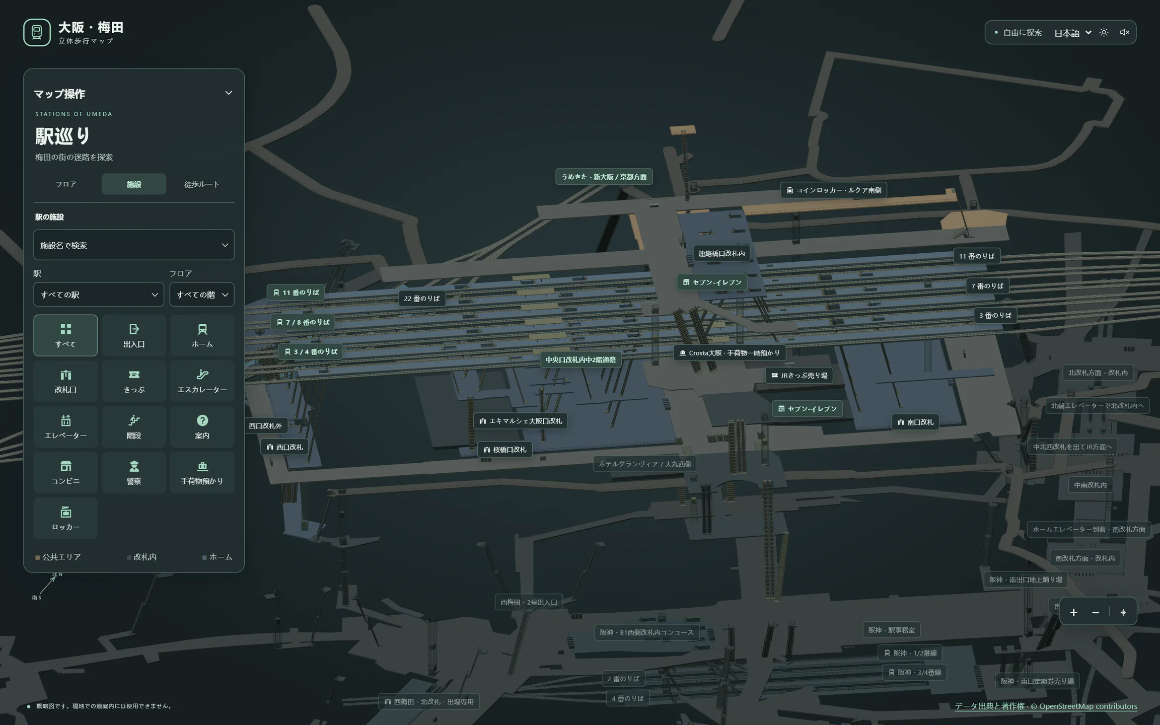
Turning a floor plan into an inventory of levels, facilities, and adjoining spaces is a good first task for AI. Once I had that inventory, I could use the project’s data structure to build an initial model.
When modeling the underground network, the guide maps lacked precise positioning data, so tracing them directly could put passages in the wrong place or send them in the wrong direction. I used OpenStreetMap to establish a street-level reference, then gave the AI road alignments and the locations of entrances I could confirm, including stairs and elevators. It checked those anchor points against the underground guide map so I could adjust the positions and alignments of the passages.

As I worked on the model, I found that GPT was more likely to get details wrong when the context grew complicated. I often went back to what I remembered from walking around Umeda and corrected details myself. I had better results when I asked the AI to verify a detail against the sources or gave it a piece of evidence it could use to make the correction. Often, just starting a fresh conversation helped a lot.
Animating the Guided Tour
Once the model was ready, I wanted people opening the map for the first time to get a clear view of how the district’s pedestrian network fits together. I asked AI to help design an automated camera tour. Each stop has a station, camera angle, floor, and time to linger. During the tour, the camera moves smoothly between viewpoints, floors fan out or fade as needed, and the accompanying notes change with each stop.
The tour opens with a wide view of Umeda before moving in toward JR Osaka Station. The camera circles the station roof, and the floors separate to reveal the third-floor bridge. As it turns toward Umekita, the upper levels fade, bringing the underground concourse and platforms into view. It then passes through Hankyu, several subway stations, and Hanshin before returning to the overview.
I also added an Osaka Loop Line train that pulls into JR Osaka Station, stops, and pulls away, with synthesized melodies for its arrival and departure. The volume changes with the camera’s distance from the platform.
For me, seeing the train pull in and hearing that familiar tune that gets stuck in your head is what brought the map to life.
Closing Thoughts
So far, the project has only uncovered a small part of the Umeda maze. Plenty of public facilities, shops, and passages through malls still need to be modeled in more detail. It’s been a fun experiment. If someone heading to Kansai uses it to explore Umeda, or a project maintaining local open data finds it useful as a reference, that would make the work feel worthwhile.
Last modified on 2026-11-22